
- Night Sky Photos DSLR & Tripod
- Night Sky Photography with just a camera and tripod
- Aurora in the Yukon Chasing Aurora in the Yukon
- Bioluminescence Water that glows blue
- Conjunctions Transits and Conjunctions
- Meteors Meteor 'Showers'
- Timelapse The Sky in Motion
- Accessories Accessories for Night Sky Photography
- Newsletter free newsletter to help you photograph astronomical events
- Astrophotography Telescopes & More
- Blog Stories
- eBook Shooting Stars
The Haute Route: June 26 - July 1, 2004

Fifteen panoramas should be enough, and there are more pictures in the Gallery, but I've been told the story needs some words too. Perhaps I've overdone it.
Soon after moving to Scotland from Australia in 2001, I heard about the Haute Route - a high level route through the European Alps - I didn't need to hear much more. In early 2004, Claire (an Australian friend of my partner) was looking for company for some alpine adventures and we were able to fit holiday and work timetables together. So we practised glacier rescue techniques on the stairs and tried to make sense of the maps..

Walking up from Bourg-St-Pierre
As we predicted, having met in Martigny and found the train into the hills, we missed the last bus from Orsieres to Bourg-St-Pierre. Despite being 10km up the road, the locals either did not understand our pronunciation or had never heard of Bourg-St-Pierre (or both). A lady in a restaurant arranged someone to take us up the road, once everybody seemed to agree on where we wanted to go.
Day 1
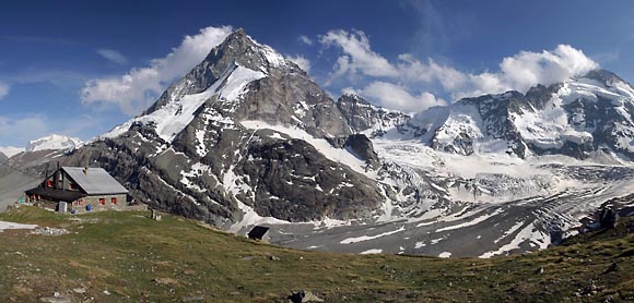
Leaving Bourg-St-Pierre, we followed the signs across the road and started on the steep tracks through green hillsides, with the sound of cowbells ringing around us. As we gained height, the first views of snow covered mountains opened up in front and we left the cows behind. Map reading and route finding began early, and the effects of the altitude not much later. We stopped on the Grands Plans plateau at around 2500m with the Cabane de Valsorey visible high up on the side of the Grand Combin.

Mont Velan from the Grands Plans
Treading carefully across the first patches of snow we reached Valsorey for lunch; the spectacular mountain scenery already confirming the route's reputation. We were, however, a little surprised to discover that the hut had only just un-officially opened for the summer season. After some time to recover, we put on our alpine gear and found a spot in the snow above the hut to practise glacier travel, crevasse rescue and ice axe arrests. I was more than a little daunted looking at our planned route up the side of the Grand Combin, but the shock came later when I realised the hut warden wasn't joking when he recommended a 3am breakfast for the following day.

Sunset from Valsorey Hut
Day 2
Despite the very early start under torchlight, it was apparent that the temperature overnight had been relatively mild - the steep ascent and altitude made all the harder by the effort required to climb up through deep snow with only a frustratingly thin crust.

Reaching the col below the Grand Combin
At the exposed top of our climb, we quickly began to cool down. We took a short stop for photos, discussed our route around the top of the Sonadon Glacier and then roped up and headed down. Back up at the Col du Sonadon, we found ourselves in the early morning sunlight, with a great view down the Mont Durand Glacier, where a pair of skis would have been a nice accessory.
The descent down the left hand side was easy enough with completely new scenery and spectacular ice falls on our left, but we were conscious that the snow was already very soft and the sun warming up quickly. It also appeared that we were the first people down Mont Durand since the end of the winter season. We chose our point to cross the glacier, but with plenty of late season snow we could see that many crevasses were covered. Sure enough, we 'uncovered' two, the second one large enough to give me plenty to think about.

Down the Mont Durand Glacier
We continued treading carefully across the glacier, but it was hot work in full sunshine and soft snow. It was a long traverse to reach ground we were more comfortable on before we could continue the descent at a faster rate. Later, looking back we could see the impressive ice fall we had traversed above. The only problem - that I was already exhausted and the hut and lunch were still a long way off.
It was a long slog down the lower sections of the glacier, and steep ground below it before finally reaching the bridge only to be faced with a mentally devastating 350 metre climb back up to Chanrion Hut. That my bowels continued to be slightly dis-functional was not helping. This was certainly one of the most physically and mentally demanding days hiking I have experienced - I knew the Haute Route would be tough, but with this as our second day I couldn't believe how so many people could manage it!
Day 3
Following a long night's sleep to recover and with an easier day ahead, we set off from Chanrion Hut proud to be out earlier than the large French group staying with us. We quickly lost that lead, heading downhill before realising that the turn-off to the Otemma Glacier was closer to the hut (mixed language conversations with hut wardens about directions to a particular track are really not very beneficial).

Cabane des Vignettes
Through the rugged valley and then the rocky, sometimes difficult moraines, we made our way up and onto the base of the Otemma Glacier. It was quite enlightening to realise that the whole lower section of rock and dirt, below the snow line and apparent melting point, was actually encased in ice and still very much part of a solid glacier. Although the French group were travelling un-roped, following our previous days experience we were taking no chances despite the gentle nature of this huge, but only very gently sloping expanse. Again in hot sunshine, we kept plodding up with the glacier disappearing in the distance ahead of us, the 'flat and tedious' route tempered by spectacular mountain scenery on either side, each day different from the last and each glacier having a completely different character.
From the Col des Vignettes, there was a short steep ascent before arriving at Vignette's Hut, precariously situated on the shear mountain side, 1000 metres above the Arolla valley below it. I had never stayed anywhere so remarkable. The location also gave us a clear view of the route for the following day; back across the plateau and up to the Col de L'Eveque and then down the Arolla glacier behind Mt Collon, before reappearing in the valley we could see below us, only to have to climb back up 800m to the Bertol Hut we could just make out at 3300m on the ridge on the far side. I'd survived our easier third day, but could not quite believe the guide book which said that all this could be achieved in seven hours?!

Col de Charmotane as the clouds clear
Day 4
Despite some doubt about the weather, we headed out and were rewarded with beautiful views of the surrounding peaks in the early morning sunlight, with the clouds drifting through. The short climb to the Col de L'Eveque was again made much harder by the thin icy crust of snow, rarely enough to take our weight but more than enough to double the frustration.

Descending past Mont Collon
With some difficulty, we chose our route down the top section of the Haut Glacier d'Arolla, before reaching easier ground and a very enjoyable descent around the back of Mont Collon in broad sunshine. Only the thought of the climb still required giving us any doubt.

Haut Glacier d'Arolla
Still in good spirits, we chose a nice rock for the lunch we had carried from Vignette's hut. Although hard work, we made steady progress up the steep Bertol Glacier, and with a great sense of achievement climbed the ladders and chains to Bertol Hut, even more precariously perched than the previous night and arguably more impressive.

View from Cabane des Bertol
Having achieved what seemed insurmountable the previous evening, we could look back to Vignette's Hut and marvel at the days route, with time to enjoy a perfect mountain sunset and the tip of the Matterhorn now in view - our destination for the next day.

Sunset from Bertol Hut
Day 5
Now comfortably in the routine of early starts and keen to be first out onto the snow, we were soon heading towards Tete Blanche, this time making quick progress and enjoying the hard frozen snow. Progress soon slowed as we reached steeper slopes. One crampon step after another, we inched our way up towards and onto the flat topped Tete Blanche - an emotional moment reaching the first summit on the route at 3707m and simply awesome views with perfect blue skies and sunlight all around. (see panorama at top of page)

From Tete Blanche, towards the Matterhorn, Dent d'Herens and Tete de Valpelline
When our companions from Bertol Hut arrived, amid many exclamations that needed little translation, we enjoyed the kind of moment that inspired us to attempt the trip. There had been much worthwhile discussion of routes down the Stockji Glacier the previous evening, and while the others intended to reach Zermatt that day, we only had to reach Schonbiel Hut. However, we followed them down, feeling much more comfortable letting a dozen others choose the route down between impressive crevasses. Further down, they chose to head around the right side of the smaller rocky Stockji ridge below us, while we chose to stick to our plan, which would hopefully be easier given the conditions.
We traversed along the back of the Stockji ridge, till we reached the steep couloir, covered in snow as we expected and required. However, accessing it from the ridge was more difficult. With a little stumble, we made our way down the unpleasant loose rock onto the snow. Relaxing at that point was a mistake, as I lost my footing and went for slide, before eventually self-arresting in the soft spring snow. What was supposed to be a quicker and easy route down turned out to be tedious and surprisingly difficult.
We could have looked for easier access to the coulouir, or turned back to a zig-zag path at Pt 3041 on the maps which would have brought us down to the other parties on the Zmutt Glacier. We learnt the lesson - persevering when our route proved more difficult than expected, to prove a point, was a mistake. After a tedious finish across the moraines at the base of the Schonbiel Glacier, we reached the hut and could look back up to the summit of Tete Blanche where we had started the day.
The Matterhorn and Schonbiel hut
Day 6
Despite the cold valley wind, I rose early enough to glimpse a short lived sunrise over the Matterhorn, before the clouds overwhelmed it.

Sunrise on the Matterhorn
Our last few hours on the Haute Route brought us down to Zermatt and back to civilisation. There were many people taking morning or day walks in the opposite direction, and our main entertainment was trying to guess which language they would greet us in. There was little joy arriving in the tourist trap of Zermatt, but without doubt the Haute Route had been as impressive as I hoped, and every bit as challenging.
If you're looking for more info, I also recorded some details about books/maps etc: http://philhart.com/adventures/haute_route_notes
Twitter Updates
Due to clouds, several pixels were harmed in the production of this composite of moonrise and lunar eclipse from 8t… https://t.co/Ew3gPZXZKc
1 year 4 months ago

